- 注册
- 登录
- 小程序
- APP
- 档案号

OMA · 2020-12-21 14:20:25
中国武汉——武汉长江主轴总体规划概念设计
×Scroll down to view English version×
武汉,源自长江流域的三大历史古城武昌、汉口及汉阳,是当代中国第九大城市。 该城市具有多元化的建筑,揉合了中国古代、租界时期及当代的建筑特色。 长江作为该城市及其周边地区的生命线,从中间贯穿这座大都会,将它分为滨江两岸。
滨江水岸现状缺乏独特性,未体现出这块腹地所具备的多样性。而该处水域由于季节性洪水导致的水位波动可高达 7 米,此进一步加剧两侧的分离,并迫使城市打造防洪墙系统等防御性基础设施,以防止江水灌入周边区域。然而,这道防洪墙一方面为周边地区提供防洪保护,但另一方面则使武昌与汉阳及汉口彼此分开,并将这三个城区与长江分离。
在持续受洪灾危害的背景之下,江河成为了一种威胁而非一种资产。如何找回沿江地带的内在价值?长江能否成为武汉城市活力的一分子,而又不会对其造成危害?
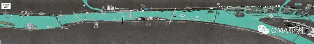
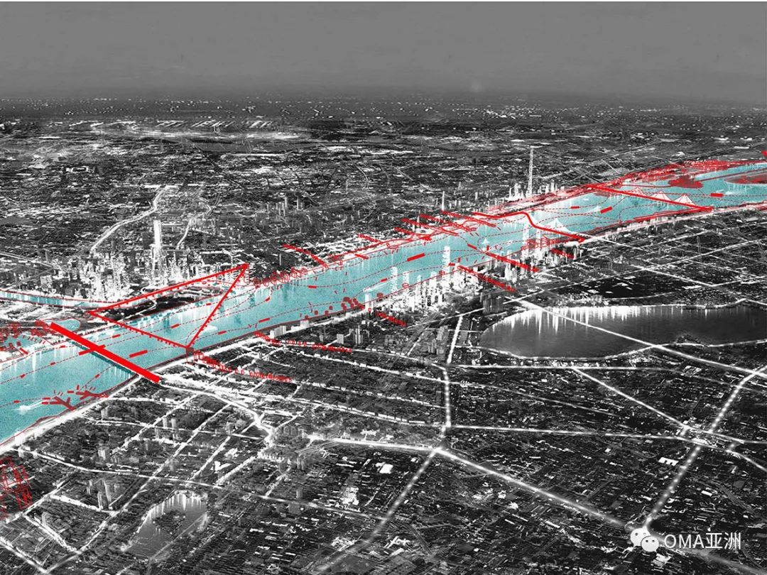
武汉水岸 总体规划方案 针对长江武汉段 25 公里长的两侧沿岸的发展提出综合性策略,以恢复长江在武汉市的重要地位。相比于仅仅美化现有的防洪墙,本总体规划方案旨在透过结合基础设施、文化及景观,将武汉与长江连接起来,以提供一系列城市空间,同时也彰显出武汉的品质。
为了改善现有的基础设施,我们建议优化水岸及武汉不同地区的连结,将目前正直接架在江岸之上切断了市中心与长江联系的沿江高速拟扩展路段往内陆迁移,并改为过江隧道的形式。 除此之外,方案还提出轮渡网络扩展、缆车连接及设置一条单轨电车,这些措施亦将为沿江两岸之间的通行以及与市中心南北侧已规划的公共文化功能及住宅发展项目的连接提供更快捷的途径。
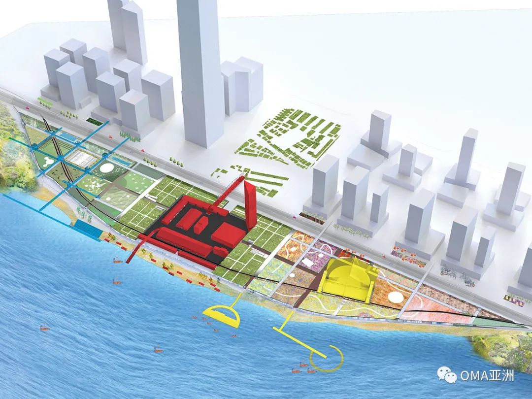
总体规划方案 的最终目标是让人们可亲近江河及堤岸的同时,减低季节性洪水泛滥的风险。为此,本规划设计重点聚焦于北区、中区及南区这三个主要段落。
核心段——为市中心注入活力
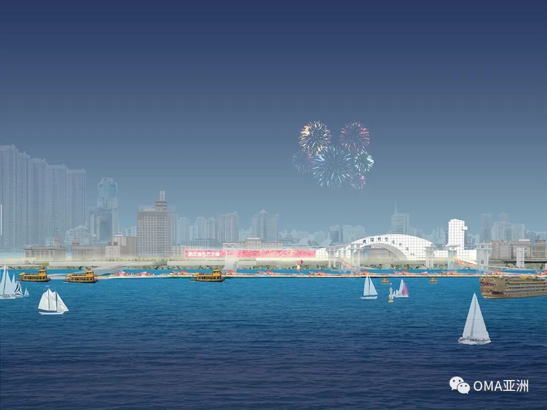
核心段充满着富有特色的汉阳、汉口及武昌旧城区现有结构及建筑,各自都拥有显赫的历史。该区域的防洪系统经过多年来的广泛发展,在城市与江岸之间形成了一道硬性边界,令江岸变得难以通达。由此导致产生了当前以兼作蓄水截洪设施的空旷寂寥的公园,又或以细窄坚硬的防洪墙为基础的设置。本段规划设计的重点任务是通过广泛多样的介入措施,例如 “ 城市阳台”,将沿江城市肌理与江畔,以及长江沿岸之间联系起来,为本区注入活力。这些介入措施包括两座大桥、一条人行步道、一条连接长江两岸的缆车线路及两个可眺望江景的公共广场(月亮湾及江汉关城市阳台)。
月亮湾城市阳台
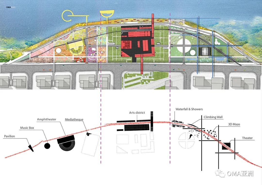
月亮湾原为旧工业火车站遗址,位于长江东岸。其基地情况较为特殊,该区段防洪墙往外侧江面凸出,与周边的江滩公园形成对比。 OMA 提议打造一个以高架公园及下沉公园共同组成的特色双层城市景观系统。城市阳台的格局按照毗邻的新中央商务区的矩形网格布置,与江岸的有机形态形成鲜明对比。本区段将形成一个文化机构区域,并将城市与防洪墙连接起来,其中由旧村落活化改造而成的工作坊及其他艺术设施以及一个户外剧场将被打造成为该区段的亮点。
江汉关 城市阳台
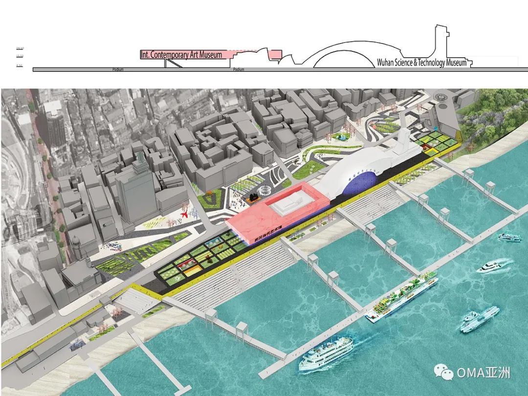
江汉关 是富有租界特色的汉口江畔的一个公共广场,位处长江西岸,邻侧是该市主要渡轮码头。为了突显此处历史风貎的重要性,区域道路、高速路及停车场将改为隧道形式,改道至我们建议的一个宽敞的广场底下。由此使该广场成为富有休闲氛围的步行区。现有的科学馆位于沿江大道旁的旧渡轮码头大楼之内,周围围绕着高架公园上可观赏长江风光的更为开敞的空间。在其现有文化功能基础上,方案加入了一个当代艺术博物馆,以作为科学馆的扩展延伸,此将会巩固强化其文化性质,从而提高了本区段作为武汉文化中心的特点。
北段 ——城市伸入水域
武汉 北 区的 开发程度较低 ,富有浓厚的住宅区氛围 。 我们建议于本区采用介入措施,对道路网络进行路线调整并改道至水域,提供一个全新的临水生活形式。例如,我们提出在陆地与江河之间打造一系列堤坝,以产生可容纳季候性洪水并转化为运河河道的一连串街道。城市景观将随着水位高度而有所改变,水位较低时会有更多的公共空间,而当水位较高时,江水会上涨至正好在建筑物首层地面之下的高度。多条大桥与通道的建设将确保运河两侧之间的连通性在任何时候都不受妨碍。
南段——水域伸入城市
过去, 武汉南部的沿江区域 具有显著的工业特色。近来,这些前工业区已发展为一个个封闭围合式的住宅社区。我们提议将这些小区改造为多元化的综合用途街区。其中新长江大桥将是该项重新开发的主要部分。大桥上将设置各式餐厅、美术馆及商店,相继排列开来形成多个 “ 站点 ” ,为前往对岸的路途制造一个充满活力的过渡区。此外,坐落于武昌南边的一座旧船厂遗址将被更新改造为酒店及休闲娱乐设施,并且将配设有公共轮渡服务连接江河两岸。
图片版权归OMA所有。
Wuhan Yangtze River Waterfront Masterplan – Wuhan, China
Wuhan, originating from the three ancient cities of Wuchang, Hankou and Hanyang along the Yangtze river, is the ninth biggest city of contemporary China. The city is characterised by architectural diversity, with a mix of ancient Chinese, colonial and contemporary architecture. The Yangtze river functions as a lifeline for the city and its surrounding areas - it crosses the metropolis right through the middle, separating it in two riversides.
The waterfronts of the riverbanks lack distinctiveness and do not translate the diversity of the hinterland. Seasonal flooding, which causes fluctuations in the water level of up to 7 meters, exacerbates the separation between either side, and has forced the city to create protective infrastructure—such as a floodwall system—to prevent the river from flooding surrounding areas. This floodwall, however, is a double-edged sword: on the one hand, it offers the surrounding areas protection against flooding; on the other hand, it disconnects Wu and Han from one another and from the Yangtze river.
In a context of constant flooding peril, the river has become a menace rather than an asset. How can the waterfront’s inherent value be retrieved? Can the Yangtze river be an active part of Wuhan without endangering it?
Wuhan’s waterfront masterplan proposes to reinstate the importance of the river within the city through a comprehensive strategy for both sides of the river section that runs through Wuhan, along 25km. Rather than simply beautifying the existing floodwall, it aims at connecting Wuhan and the Yangtze river by combining infrastructure, culture and landscape to provide a range of urban spaces, and pronouncing the qualities of Wuhan.
To improve the existing infrastructure, we suggest to better connect the waterfront and different areas of Wuhan by moving the proposed highway extension—which now runs directly on the riverbank and cuts off the city centre from the water – further inland and into a tunnel below the water surface. Additionally, a ferry-network extension, cable-car connections and a monorail will provide faster connections between both riverbanks and to the proposed cultural public programmes and housing developments north and south of the city centre.
The ultimate goal of the masterplan is to create accessibility to the river and its embankment, while mitigating risks of seasonal flooding. To do so, the masterplan focuses on three main zones – the core, north and south.
Core Zone – Activating the City Centre
The core section is characterized by existing structures and architecture of the old towns of Hanyang, Hankou, and Wuchang, all with a notable history. Over the past years, water defence mechanisms have been extensively developed, creating a hard boundary between the city and the riverbank that makes the waterside hard to access. This results in a current configuration based on wide, empty parks that double as water storage facility, or narrow and hard walls. The focus is to activate this area with an eclectic range of interventions, the ‘Urban Balconies’, to connect the urban tissue to the waterfront, and the river banks with each other. These interventions include two bridges, a pedestrian walkway, a cable car connecting both sides of the river and two public plazas overlooking the water – Moon Bay and Jianghan Guan Urban Balconies.
Moonbay Urban Balcony
Moonbay, an old industrial railway station, sits on the east side of Yangtze river and is a unique site where the floodwall bulges out of the city towards the river, contrasting the surrounding waterfront parks. OMA proposes to create a double-level urban landscape, featuring elevated gardens and a sunken park. The pattern of the urban balcony is based on the rectangular grid of the adjoining newly designed CBD, offering a sharp contrast to the organic form of the embankment. This zone will form a cultural and institutional area connecting the city and the floodwall, featuring a former village restored to accommodate workshops and other art-making facilities, and an outdoor theatre.
Jianghan Guan Urban Balcony
Jianghan Guan is a public plaza along the colonial waterfront of Hangkou next to the main ferry terminal, on the Western side of the river. In order to highlight the importance of the historical context here, the local road, the express highway and the parking spaces will be redirected into a tunnel below a proposed extensive plaza. As a result, the plaza will become a pedestrian area with leisure quality. The existing Science Museum, located in the old ferry terminal building beside Yanjiang Avenue, will be surrounded by more open space on an elevated plaza overlooking the river. Its cultural program will be reinforced to include a Contemporary Art Museum as an extension to the Science Museum, to enhance the character of the area as the cultural heart of Wuhan.
North Zone – City inhabits Water
The northern area of Wuhan is characterized by less development and a strong residential character. The proposed interventions in this area are based on the re-routing of the road network onto the water, which provides opportunities for new forms of living by the water. For example, we propose the creation of a series of dykes between the mainland and the river to generate a succession of streets that will seasonally flood and transform into water canals. The urban landscape of the area will vary depending on the level of the water – when the water level is low, more public space is gained; when it is high, the water will be just below the ground floor of the buildings. At all times, bridges and passages will ensure a connection between both sides of the canal.
South Zone – Water inhabits City
The riverside areas in the southern side of Wuhan have had a prominent industrial character in the past. Recently, these former industrial zones have developed into gated residential communities. We propose to turn these districts into diverse mixed-use areas. The main part of this redevelopment will be the new Yangtze Bridge – it will feature several ‘stations’ - restaurants, galleries and shops will succeed each other on the bridge, providing a lively transition onto the other bank side. Additionally, the former shipyard sites south of Wuchang will be readapted into hotels and entertainment facilities, and public ferry service will connect both sides of the river.
Image courtesy of OMA.
OMA是一间国际事务所,在传统的建筑和城市化研究框架内运作。而AMO则是一个研究和设计工作室,将建筑思想应用于传统领域之外。
OMA is an international practice operating within the traditional boundaries of architecture and urbanism. AMO, a research and design studio, applies architectural thinking to domains beyond.
特别声明
本文为自媒体、作者等档案号在建筑档案上传并发布,仅代表作者观点,不代表建筑档案的观点或立场,建筑档案仅提供信息发布平台。
17
好文章需要你的鼓励
 参与评论
参与评论
请回复有价值的信息,无意义的评论将很快被删除,账号将被禁止发言。
评论区
OMA
关注 发表 25 篇文章台北表演艺术中心
发表25篇文章
发表25篇文章
OMA / 雷姆.库哈斯及大卫.希艾莱特设计的台北表演艺术中心正式开幕
2022-08-24 20:47:00
OMA为UniFor设计家具亮相米兰
2022-06-07 10:54:10
OMA设计宜宾叠粹
2022-05-26 15:11:36
OMA设计的台北表演艺术中心竣工
2022-05-26 15:11:25
OMA/克里斯·范杜恩设计的未来新湖中心(杭州光棱)立面工程即将竣工
2022-05-26 15:11:13
OMA / 赖纳·德·格拉夫与BURO HAPPOLD公布多哈医疗健康区方案
2021-11-24 18:12:17
OMA设计的柏林卡迪威首个分区竣工开业
2021-11-17 16:48:35
OMA设计的未来·新湖中心(杭州光棱)施工图片
2021-04-14 14:49:44
由OMA设计的Potato Head Studios夺得园冶杯国际建筑奖大奖
2021-03-29 10:02:45
OMA中标成都未来科技城城市设计及建筑设计
2021-02-04 17:14:16